Category Archives: Paleogeography

Plate tectonics drive tropical reef biodiversity dynamics

A new paper is out in Nature Communications – a study by Fabien Leprieur and co-authors (including me) on how plate tectonics influences the biodiversity dynamics of tropical reefs. Previously published paleo-shoreline estimates (see data on Github and Heine et al paper) have were used as base to model paleo-bathymetry and time-dependent spatial diversification patterns of tropical marine reefs – here’s the abstract:

The Cretaceous breakup of Gondwana strongly modified the global distribution of shallow tropical seas reshaping the geographic configuration of marine basins. However, the links between tropical reef availability, plate tectonic processes and marine biodiversity distribution patterns are still unknown. Here, we show that a spatial diversification model constrained by absolute plate motions for the past 140 million years predicts the emergence and movement of diversity hotspots on tropical reefs. The spatial dynamics of tropical reefs explains marine fauna diversification in the Tethyan Ocean during the Cretaceous and early Cenozoic, and identifies an eastward movement of ancestral marine lineages towards the Indo-Australian Archipelago in the Miocene. A mechanistic model based only on habitat-driven diversification and dispersal yields realistic predictions of current biodiversity patterns for both corals and fishes. As in terrestrial systems, we demonstrate that plate tectonics played a major role in driving tropical marine shallow reef biodiversity dynamics.

The paper is available as open-access on the Nature Communications website. Associated data can be downloaded from Figshare.
Global Paleoshoreline data

Together with former Ph.D. student Logan Yeo, we’ve reverse-engineered a set of global paleoshoreline compilations by Golonka et al. (2006) [1] and Smith et al. (1994) [2] and taken them back from the age of “dark data” being only published in analogue form, to fully digital versions. The paleoshoreline models are made available publicly in different formats, ready to be reconstructed with GPlates using different plate models. The data is published on the web alongside the paper (in press) in the Australian Journal of Earth Sciences (Heine, Yeo & Muller: Evaluating global paleoshoreline models for the Cretaceous and Cenozoic, Aust. J. Earth Sciences, in press) and they show the evolution of land area over time from ~150 Ma to the present according to the two different paleoshoreline estimates.

The files are available on my GitHub page here in *.gpml, *.geojson and *.shp format and can be viewed online. Unfortunately it doesn’t seem to be possible to embed the map on wordpress.com – I originally envisaged some funky webX.X embedded mapping here, but no. Instead web1.0 style links to follow for a sneak peek and some screenshots below:

  1. Golonka et al. (2006) models (examples):
  2. Smith et al. (1994) models:

The rendering through GitHub is fast and allows a quick overview about the global and regional paleoshoreline locations, allowing zooming in and panning.

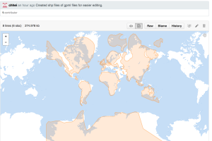
Paleoshorelines in the Golonka model for the 139-123 Ma time slice rendered from a geojson file live on GitHub.

Paleoshorelines in the Golonka model for the 139-123 Ma time slice rendered from a geojson file live on GitHub. The colored area inside the polygon is equivalent to interpreted land (above sealevel) in the given time interval.

Another option to access the data is to use the version on CartoDB and interactively query and alter the data.

References:

[1] GOLONKA J., KROBICKI M., PAJAK J., VAN GIANG N. & ZUCHIEWICZ W. 2006. Global Plate Tectonics and Paleogeography of Southeast Asia. Faculty of Geology, Geophysics and Environmental Protection, AGH University of Science and Technology, Arkadia, Krakow, Poland.

[2] SMITH A., SMITH D. G. & FURNELL B. M.1994. Atlas of Mesozoic and Cenozoic coastlines. Cambridge University Press, 112 p. Cambridge, United Kingdom.